Medieval Period


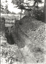
1930's excavation
Norsey Wood Deerbank
The owners of medieval woodlands constructed permanent boundaries around their properties to protect their wood, timber and hunting rights. These boundaries consisted of massive ditch and bank systems and were designed to prevent the passage of deer and cattle over them.
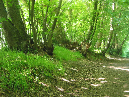
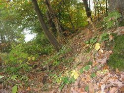
Norsey Wood possesses excellent examples of such systems, uniquely called Deerbank. Before the 1930s, these surrounded the whole wood. Today, owing to residential development along Norsey Road, which also destroyed one of the Bronze Age burial mounds, the Deerbank is fragmented. Happily, it remains still to be seen on the present eastern, southern and western boundaries. It can be viewed most easily from the Easy Access Trail by walking in an anti-clockwise direction from the Information Centre. It becomes visible on the left as soon as the entrance gate from Break Egg Hill is reached. This particular part of the Deerbank is a later construction than the original and is superimposed on the older one. If the path is followed beyond where the Easy Access Trail turns off to the right and down the slope, the bank divides in two and the northern of the two divides again, indicating three phases of construction. Two of these banks (the most southerly) possess obvious external ditches; one has evidence of an internal ditch as well (the path follows this ditch going uphill from the Larch plantation. The side on which the ditch is found is the side where the deer or cattle would have been. With a paling fence on top, the bank with its deep ditch would have been a formidable barrier for the animals to leap.
The bank with an internal ditch indicates that Norsey was at one time a deerpark - the ditch preventing the deer from escaping by significantly increasing the width to be cleared. Such parks were a common feature in medieval England and were used as hunting grounds by the Lords of the Manor and, no doubt, formed an important part of the economy. There is some documentary evidence that Norsey Wood was a deerpark.
In the 1280 Licence, it was described as a 'park', rather than a wood. On an estate map of 1708, a parcel of land close by the wood, was described as 'Stone Hills abutting upon Outwood Common'. The local names 'Outwood' and 'Outward' were used elsewhere in Essex for woodland outside a deerpark.
Needless to say, if deer were encouraged, then the practice of coppicing, the traditional management of small woods, would have been impossible. The deer would have browsed on the new shoots emerging from the cut stools.
The banks with external ditches were constructed when the wood, or parts of it, was used to produce timber by the coppicing method.
